Tall-building views
Canary Wharf, Isle of Dogs and Aldgate verified-view support where skyline, townscape or protected-view receptors matter.
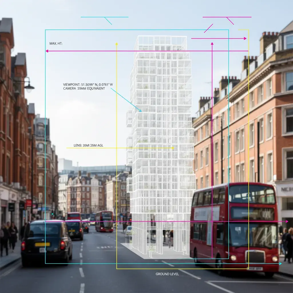
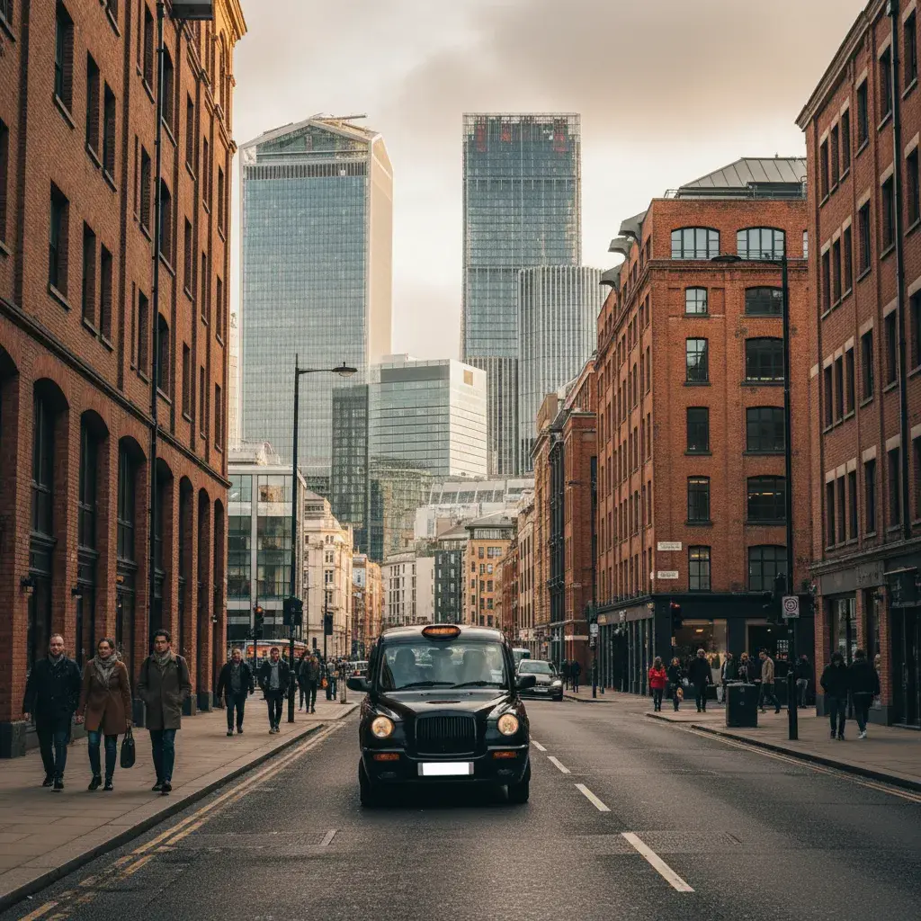
Canary Wharf and Isle of Dogs tall-building schemes require verified views and AVRs scoped against London View Management Framework receptors and Tower Hamlets tall-building policy, with viewpoint selection, survey control and camera matching agreed before photography begins.
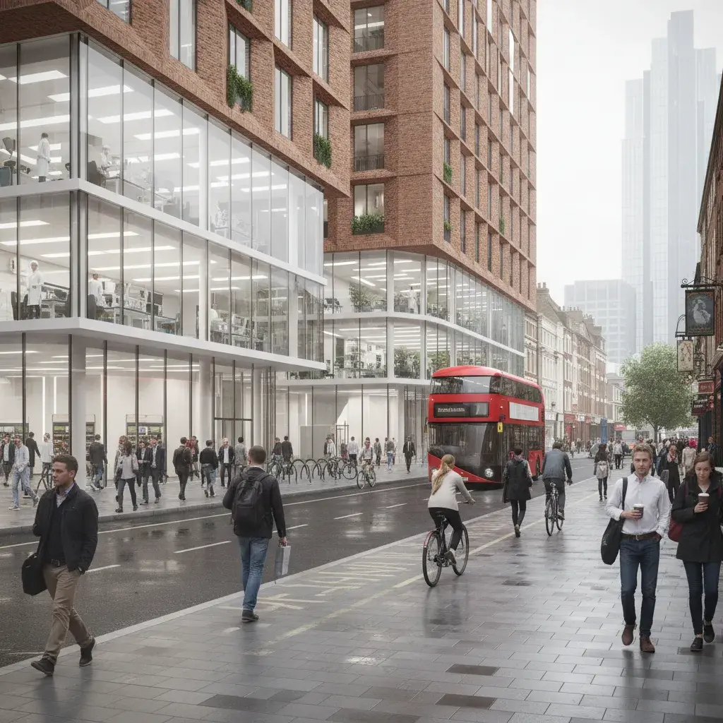
Whitechapel and the City Fringe, anchored by the Barts Life Sciences Cluster, require interior and facade CGI that documents lab layouts, glazing performance and finish specification for life-science occupiers, hospital-adjacent workspace and developer review. South Poplar, Billingsgate and Poplar Riverside masterplans need aerial, eye-level and cumulative-skyline views that resolve phasing, dock-edge public realm and the transition into Canary Wharf scale.
Tower Hamlets Council submissions often need visuals that make scale, materials and street context easy to understand.
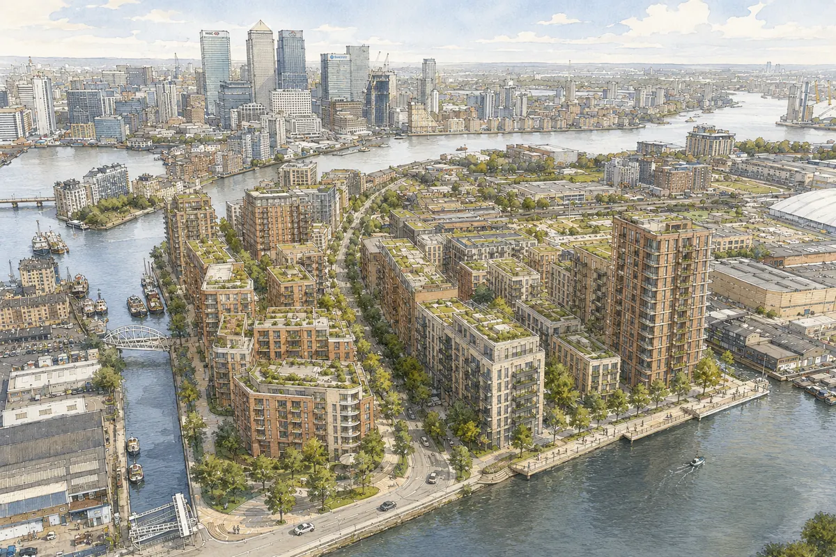
Tower Hamlets has the highest raw development volume of any London borough we cover: 58 conservation areas, a 52,000-home Future Places pipeline, and up to 10,000 new homes at South Poplar and Billingsgate alone. The borough combines six visualisation contexts: Canary Wharf and Isle of Dogs towers; South Poplar and Billingsgate estate and market-site growth; Whitechapel life-science around the Royal London Hospital and Barts Life Sciences Cluster; Brick Lane and Banglatown heritage frontage; Aldgate and City Fringe commercial expansion; Hackney Wick and Fish Island creative-industrial conversion. A Tower Hamlets CGI package must show height, townscape effect, public-realm benefit and retained local character in a single image set.
CGI is most useful in Tower Hamlets when the planning question depends on scale, skyline, view impact, active frontage, retained fabric, public-realm connection or the difference between planning evidence and commercial presentation.
Canary Wharf, Isle of Dogs and Aldgate verified-view support where skyline, townscape or protected-view receptors matter.
Tower Hamlets Council visuals for design statements, consultation packs, committee material and pre-application review.
South Poplar, Billingsgate, Poplar Riverside and estate-edge CGI for public realm, massing and phasing.
Canary Wharf, Aldgate and Whitechapel workspace, life-science, hotel, retail and mixed-use visualisation.
Brick Lane, Banglatown and Whitechapel material studies where shopfront, upper-floor change and culture-led context matter.
Hackney Wick and Fish Island warehouse, canal-edge and creative-workspace images for planning and presentation.
Tower Hamlets Council requires computer generated visualisations on all major planning applications, with view format and level of detail set through pre-application discussion based on scale, prominence and sensitivity. Visuals should be scoped against the Local Plan, tall-building guidance, conservation-area context, townscape receptors, daylight and sunlight constraints, and any requirement for verified views, digital 3D modelling or a Townscape and Visual Impact Assessment. Canary Wharf, Isle of Dogs, Whitechapel, South Poplar and Aldgate schemes often need a stricter visual method than a generic marketing render.
Tower Hamlets Council names computer generated visualisations on its local validation list and treats CGI as a mandatory submission item for major developments. The aim is to illustrate likely visual impact and show the proposal in its real townscape, dock-edge or heritage context, not to provide a marketing render.
A Tower Hamlets CGI brief should cite this validation requirement directly. Confirm with the case officer or planning consultant whether verified views, AVR or TVIA support are also expected for the site.
Source: Tower Hamlets Council, CGI visualisations local validation guidance
Verified views are central to many Tower Hamlets briefs because height, skyline, dock-edge context, townscape, heritage setting and public-realm impact often determine how a project is assessed.
A Tower Hamlets project may need verified views or AVR where it affects a tall-building zone, skyline receptor, dock-edge view, conservation-area setting, strategic view, heritage asset or major mixed-use planning route. The project team should agree viewpoint purpose, photography method and model inputs before production begins.
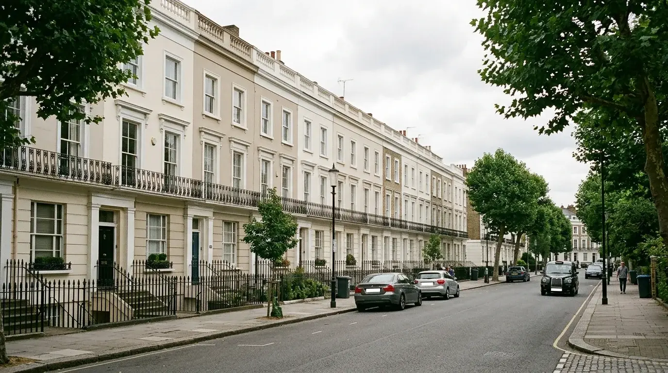
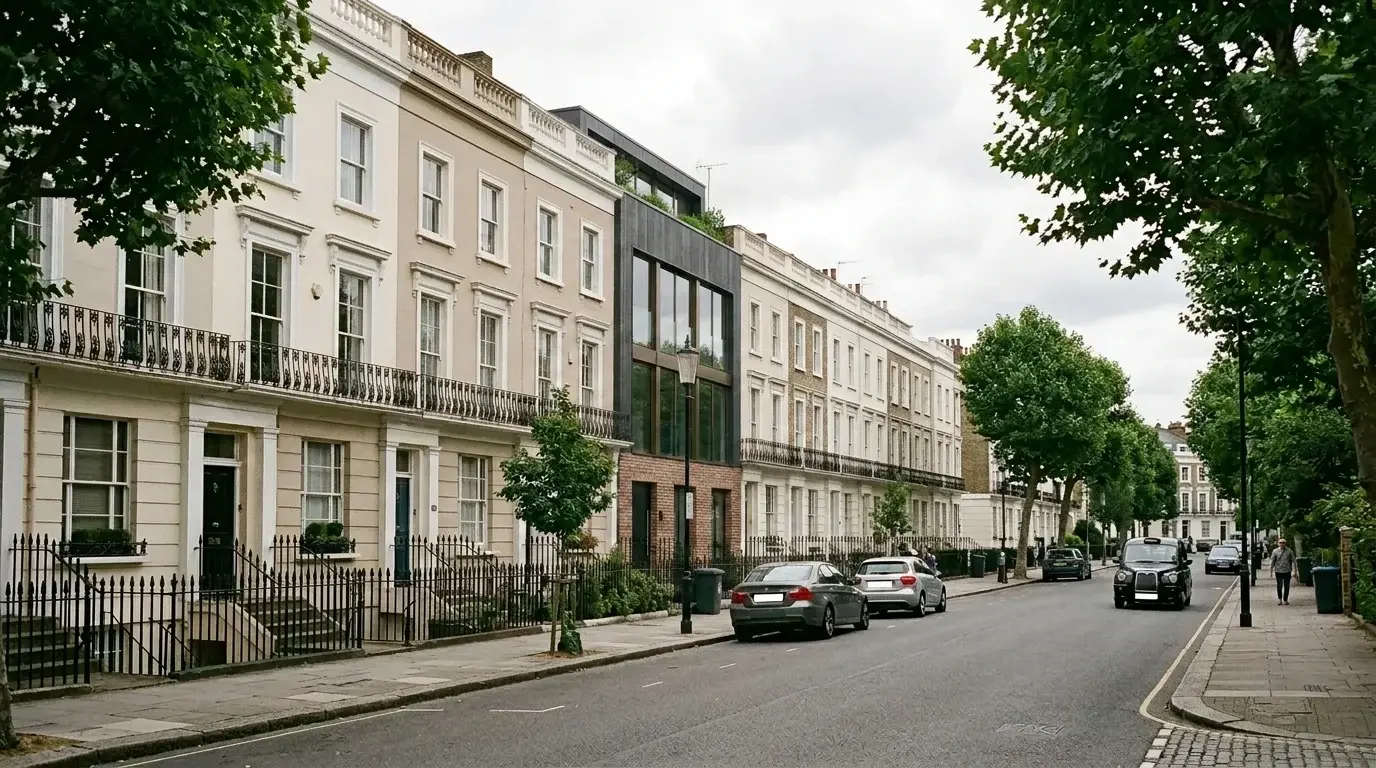
The first view acts as the surveyed AVR baseline: the existing Tower Hamlets street scene is held in the agreed camera position, with the proposed-development zone, viewpoint information and facade callouts marked for review. The second keeps the same view and annotation logic, then visualises a contemporary facade intervention within the conservation-area terrace so the planning team can compare existing context and proposed change directly.
For teams comparing routes, planning application visuals can cover design explanation and committee-pack imagery, while verified views are scoped when the viewpoint, survey relationship and methodology need to be documented.
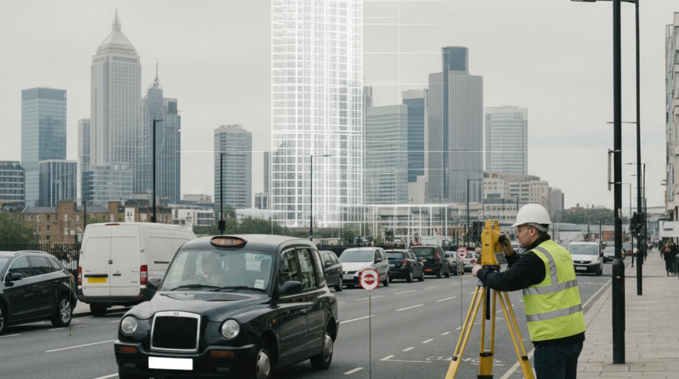
For Tower Hamlets projects that take the verified-view route, the methodology runs through four stages: viewpoint scoping, surveyed photography, camera matching against the 3D model, and final photomontage or AVR reporting.
Relevant references include Landscape Institute Technical Guidance Note 06/19: Visual Representation of Development Proposals, London View Management Framework where relevant, Tower Hamlets Council planning and validation requirements, project-team planning and townscape consultant requirements. If the Tower Hamlets brief may need AVR, agree the view route before photography, survey control and camera positions are fixed.
Tower Hamlets has one of London's most concentrated visualisation mixes: tall-building verified views, dock-edge residential towers, life-science and hospital-adjacent workspace, market-site masterplanning, City Fringe commercial retrofit, Brick Lane heritage frontage and Hackney Wick creative-industrial reuse.

Show tower massing, dock-edge visibility, skyline effect, public-realm impact and verified-view methodology for residential, commercial and mixed-use schemes.
Explain lab, workspace, hospital-adjacent frontage, public realm, Elizabeth Line arrival and heritage context for planning and commercial audiences.
Communicate estate renewal, market-site redevelopment, new homes, bridges, public space, route hierarchy and the transition into Canary Wharf scale.
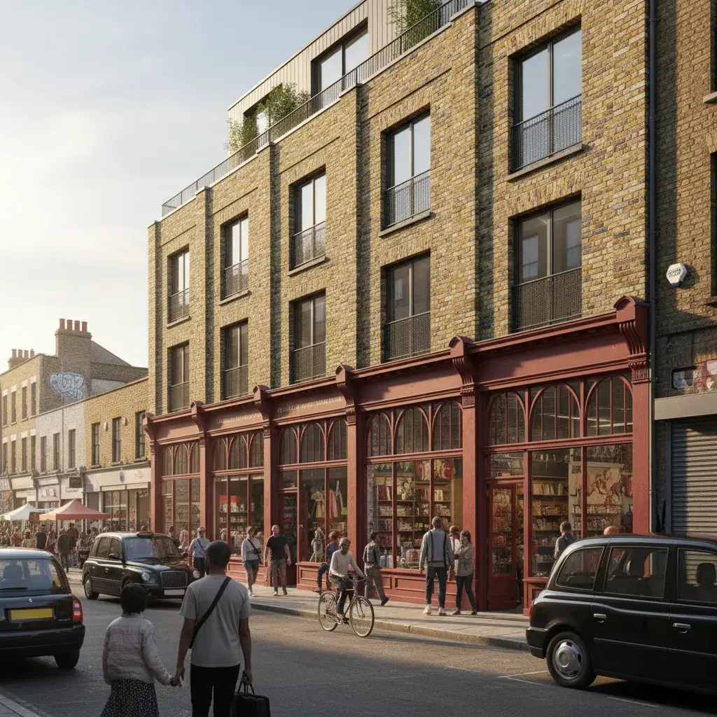
Show retained shopfront rhythm, signage, upper-floor change, material tone, cultural context and pedestrian life without flattening the street into a generic mixed-use view.
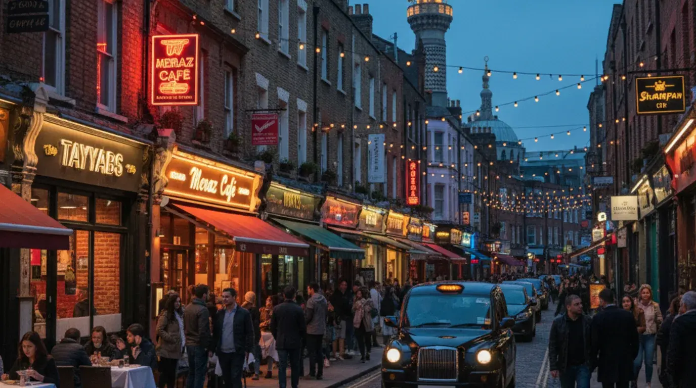
Capture evening trade conditions on the Banglatown stretch of Brick Lane: lit curry-house frontages, retained Victorian shopfront rhythm, signage, string lighting and pedestrian dining context that daytime visuals miss.
Present office, hotel, retail, workspace and mixed-use frontage where City-scale commercial demand meets Tower Hamlets planning and townscape constraints.
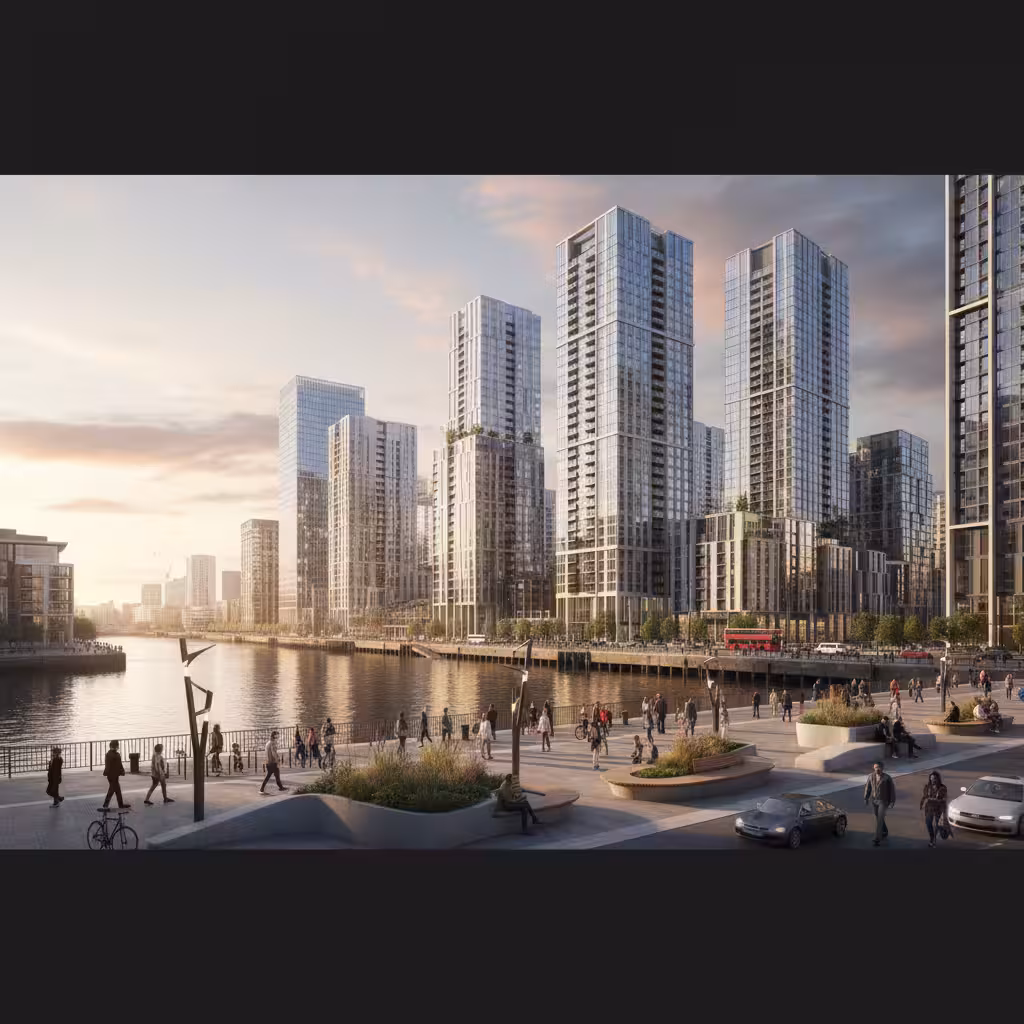
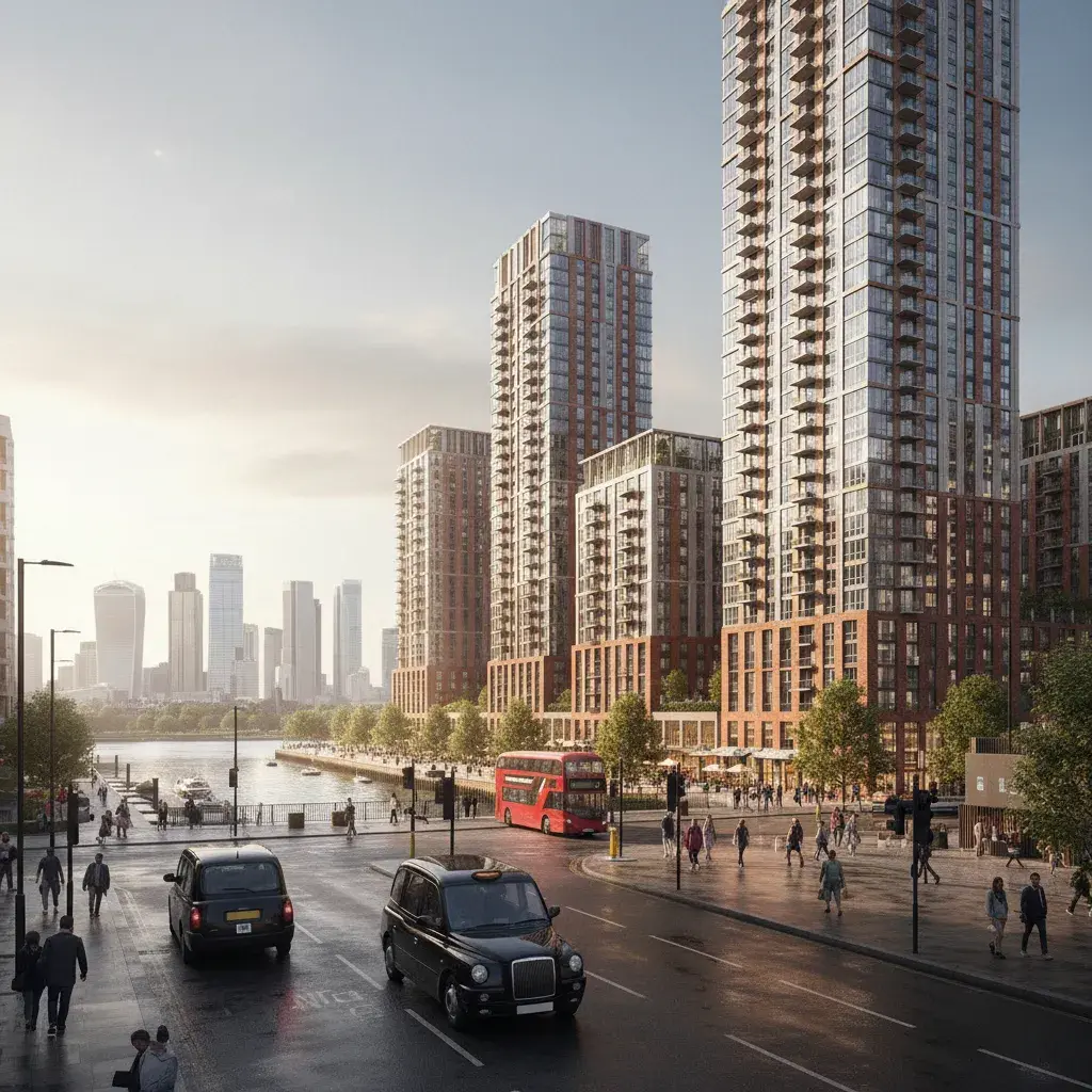
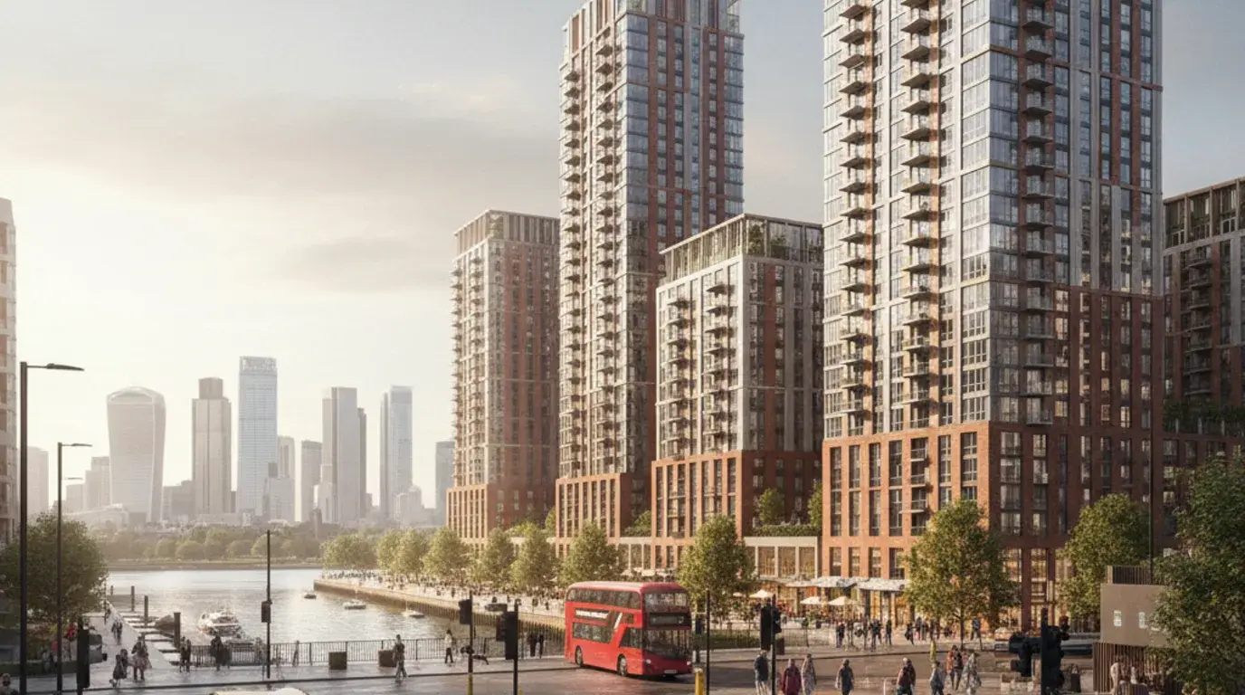
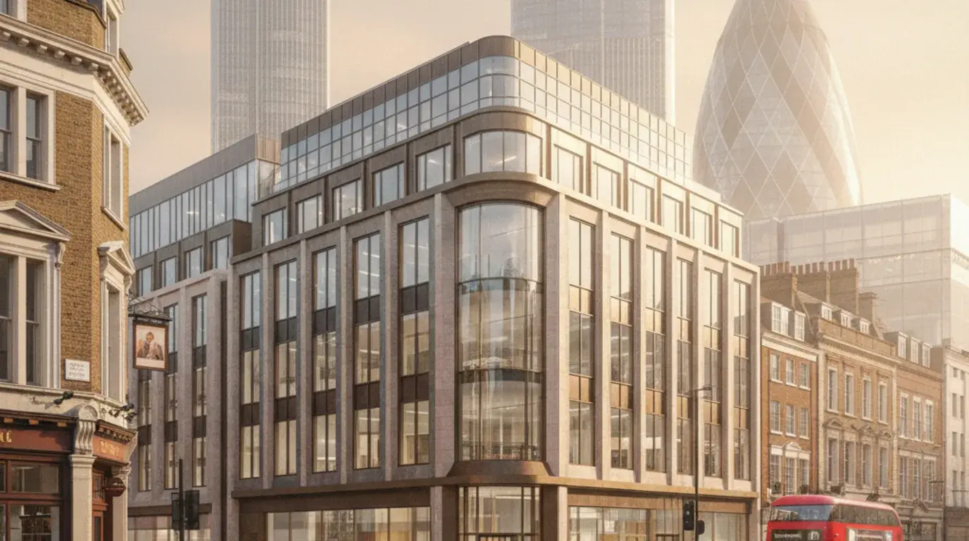
Canary Wharf and Isle of Dogs briefs need more than a polished tower render. The visual package must explain six things: skyline position, dock-edge relationship, public-realm effect, lower-level frontage, neighbouring tower context, and the camera method used to test the view. Tower Hamlets Future Places identifies Canary Wharf as a major commercial, residential, retrofit and tall-building opportunity. Wood Wharf will deliver more than 3,500 homes, and North Quay carries Europe's largest life sciences laboratory under construction.
A Tower Hamlets verified-view package can include baseline photographs, wirelines, massing studies, AVR or photomontage outputs, VU.CITY or 3D model inputs, TVIA figures and planning-report images. The stricter the view receptor, the earlier the team should agree photography, survey control and model alignment. The Isle of Dogs and South Poplar Opportunity Area targets 29,000 homes and 110,000 jobs by 2041. Verified-view briefs there typically have to test cumulative skyline change, not just a single proposal. Our Isle of Dogs office tower CGI case study sets out how six planning-review views and four marketing CGIs were scoped against this kind of tall-building context.
A Tower Hamlets tall-building package can include baseline photography, AVR or verified views, wireline and massing overlays, dock-edge photomontages, skyline receptor views, planning-report images, committee visuals and commercial presentation variants. Each output should be tied to a planning or design decision rather than produced as a generic render set.
For Canary Wharf and Isle of Dogs, the same model may need a strict planning output and a more polished presentation image. Separating those outputs keeps the planning consultant clear on evidence while the developer still has commercial material for investors or leasing teams.
Tower images can fail when they show only the upper skyline. Tower Hamlets reviewers also need to see how the proposal meets the ground: dock edge, pedestrian route, entrance hierarchy, wind-mitigation landscape, active frontage, servicing and relationship to nearby residential or commercial towers.
The strongest image set therefore combines a long-range or verified view with lower-level street or dock-edge views. The long-range view tests visibility and skyline effect. The lower-level view tests public realm, frontage and daily use.
Whitechapel is a different visualisation problem from Canary Wharf. The page angle should connect life-science workspace, hospital and university context, Elizabeth Line movement, heritage streets and public realm. A useful image proves how the building works at street level before it tries to sell the architecture. Barts Health has announced up to £800m backing for the Barts Life Sciences Cluster around the Royal London Hospital, with the Whitechapel development expected to generate over 5,000 jobs.
For this typology, planning visuals should show frontage, massing, material tone, patient or pedestrian routes, servicing, active ground floor and any conservation-area context. Commercial imagery can then use the same model for lab, workplace, lobby or investor presentation once the planning evidence is separated. Tower Hamlets Future Places ties Whitechapel to Barts Life Sciences, the Whitechapel North and South allocations, Elizabeth Line connectivity and public-realm improvements, so a single image rarely carries the full argument.
Whitechapel life-science CGI should show more than a laboratory facade. The image must explain hospital-adjacent movement, public realm, arrival, ground-floor use, service access and material tone, all to readers who are assessing the project through planning, health-campus and commercial lenses simultaneously.
A single hero image will not usually carry that whole argument. Useful sets combine street photomontage, facade material study, lobby or workspace interiors, public-realm views and selected planning figures for the consultant team.
Whitechapel and Brick Lane-adjacent sites can sit close to sensitive frontages, historic street patterns and busy pedestrian routes. CGI should show signage, shopfront rhythm, upper-floor changes, brick tone, glazing depth and entrance hierarchy without turning the street into a generic innovation-district backdrop.
Where a scheme needs commercial polish, the planning set and marketing set should still stay separate. Planning images should be restrained enough for evidence. Presentation images can add atmosphere after the material and context decisions are fixed.
South Poplar and Billingsgate is the next major Tower Hamlets growth zone, with Future Places identifying up to 10,000 new homes across the Billingsgate Market site, Aspen Way and the Poplar estate edge. The visual problem is not just massing. The visual problem covers route hierarchy, market-site redevelopment, estate edge, public realm, bridge connections, and the transition into Canary Wharf scale.
A useful masterplan set has to stitch Poplar to Canary Wharf in image form. That means aerial or high-oblique views for phasing and cumulative scale, plus eye-level photomontage along Aspen Way, the proposed bridges and new public spaces. Planning, consultation and investor audiences each need different cuts of the same model, so the brief should separate evidence views from atmosphere views early.
South Poplar and Billingsgate masterplans usually need an aerial or high-oblique image that shows the market-site footprint, Aspen Way, the Poplar estate edge and the Canary Wharf skyline in one frame. Phasing variants of the same view help committee, GLA and consultation audiences read sequence and cumulative effect.
The aerial set should be paired with at least one eye-level public-realm view so the masterplan does not stay abstract. The eye-level view tests how new routes, bridges and ground-floor uses behave in everyday pedestrian terms.
A core visual question for South Poplar and Billingsgate is how the new neighbourhood connects to Canary Wharf without being absorbed by it. CGI should make bridge connections, route hierarchy, scale transition and public-realm continuity readable, so reviewers can see where the masterplan stitches and where it deliberately steps down in height.
Heritage and existing-community context still matters here. Visuals should show retained estate fabric, market heritage references and active ground-floor uses alongside the new massing, not flatten the area into a generic regeneration render.
Service scope on a Tower Hamlets brief follows planning risk. Verified views handle tall-building and skyline effects. Planning visuals handle consultation and committee review. Commercial CGI suits Canary Wharf and Aldgate. Masterplan visuals cover South Poplar and Billingsgate. Material studies fit Brick Lane and Whitechapel heritage settings.
AVR, verified-view and photomontage support for Canary Wharf, Isle of Dogs, South Poplar, Aldgate and Whitechapel schemes where skyline, townscape or receptor evidence is required.
Discuss this service Planning Application VisualsTower Hamlets Council planning visuals for design-and-access statements, pre-application review, consultation, committee packs, TVIA support and material evidence.
Discuss this service Commercial DevelopmentsOffice, hotel, retail, life-science, workspace and mixed-use CGI for Canary Wharf, Aldgate, Whitechapel and City Fringe briefs.
Discuss this service Exterior RenderingsFacade, street-scene, dock-edge, public-realm, roofline and masterplan views for Tower Hamlets towers, estates, canalside plots and high streets.
Discuss this service Residential DevelopmentsResidential tower, estate renewal, mixed-use block and show-apartment CGI for Isle of Dogs, South Poplar, Billingsgate, Poplar Riverside and Whitechapel projects.
Discuss this service Interior VisualisationsInterior CGI for commercial lobbies, life-science workspace, hospitality, show apartments, amenity spaces and client or investor sign-off.
Discuss this serviceNeed verified views, massing studies, TVIA figures and planning visuals that show Tower Hamlets skyline, dock-edge, heritage and public-realm effects without overstating the proposal.
Need masterplan, consultation, public-realm and commercial CGI for Canary Wharf, South Poplar, Billingsgate, Whitechapel and Poplar Riverside growth sites.
Need workplace, lab, lobby, hotel, retail and mixed-use visuals that balance leasing presentation with planning context around Canary Wharf, Aldgate and Whitechapel.
Need Brick Lane, Banglatown, Whitechapel and Wapping visuals that show material tone, retained fabric, signage, shopfront rhythm and old-new junctions clearly.
Tower Hamlets CGI needs to show how new massing behaves against skyline, dock edge, heritage frontage, estate edge, hospital or station context, public realm and pedestrian routes. The image set should separate planning evidence from leasing or marketing atmosphere. For facade, roofline and streetscape visibility, see exterior rendering support.
A Tower Hamlets visualisation package starts by identifying whether the decision is a planning submission, verified-view set, design-review pack, consultation image, investor presentation or commercial marketing output. Viewpoint method, model context and image finish then follow that decision.
Review the Tower Hamlets address, planning route, drawings, model information, site photos, viewpoint notes, deadline and intended image use.
Agree the visual purpose: Tower Hamlets Council planning explanation, verified-view support, TVIA figures, consultation, investor presentation or marketing.
Model the existing and proposed condition with enough tower, dock, street, heritage or public-realm context for the decision to read clearly.
Compose skyline, dock-edge, street, interior, frontage, photomontage or verified-view viewpoints before final rendering.
Apply materials, lighting, facade detail, landscape, people, furniture and borough-specific context, then deliver print-ready and web-optimised stills or iterations.
Tell us where the Tower Hamlets project is, what stage it has reached, which drawings or model information are ready, and whether the images need to support planning, verified views, TVIA, design sign-off, consultation, investor review or marketing.
You can also email drawings, image references and deadlines to hello@architecturalvisualisationlondon.uk.
A Tower Hamlets visualisation quote depends on the site address, height, planning route, view method and decision the imagery needs to support.
Send drawings and view requirements for a brief review and we will confirm the right visual route before quoting.
Nearby borough links connect Tower Hamlets to the east and central London planning corridor.
Southwark sits across the Thames and carries a related verified-view, commercial retrofit and regeneration image demand around Bankside, Canada Water and Old Kent Road.
Hackney connects through Hackney Wick, Fish Island, Shoreditch and creative-industrial conversion work, so internal links should reinforce that shared east London context.
The City of London and Aldgate sit at the western edge of Tower Hamlets, so commercial retrofit and tall-building view logic often crosses that boundary.
Islington connects through the City Fringe, Clerkenwell and Old Street commercial context, especially when a brief is closer to Aldgate or Shoreditch than Canary Wharf.
Not every Tower Hamlets application needs verified views, but tall-building, skyline, dock-edge, conservation-area and major mixed-use schemes may need AVR, photomontage or TVIA support agreed with the planning or townscape consultant.
Canary Wharf and Isle of Dogs proposals can depend on height, skyline, dock-edge and public-realm effects. Viewpoint selection, survey control, camera matching and model detail should be agreed early if the images support planning evidence.
Yes. CGI can show workspace frontage, lab or commercial interiors, public realm, arrival sequence, hospital context, servicing and material tone before planning submission, leasing or investor review.
Useful visuals include frontage CGI, material studies, shopfront and signage views, upper-floor massing, existing-and-proposed photomontage and streetscape images that show cultural and conservation context clearly.
Typical inputs include the site address, drawings, massing model, site photos, viewpoint requirements, planning or townscape notes, material references, image use, review-round expectations and deadline.