Verified Views and AVR for London Planning
We produce verified views, also known as verified photomontages or Accurate Visual Representations at AVR Levels 0 to 3, to the London View Management Framework Supplementary Planning Guidance (March 2012) and Landscape Institute TGN 06/19 (2019). Each set ships with a signed method statement and OS-grid-recorded viewpoints for London planning applications, townscape submissions, LVIA and TVIA evidence, and LVMF designated views.
Start the briefAVR Levels 0 to 3: how Accurate Visual Representations scale with application sensitivity
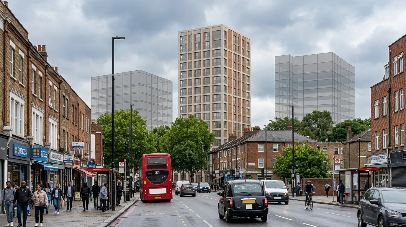
A verified view, or Accurate Visual Representation (AVR), is graded by the detail of the proposed development carried in the image, under the London View Management Framework. Landscape Institute guidance TGN 06/19 aligns the same AVR ladder to its Type 1 to Type 4 visualisations. The verified view you commission should follow the application, not the other way round.
| Level | What the image carries | Where it fits | LI Type |
|---|---|---|---|
| AVR 0 | Wireline outline of the proposal on the photograph base. | Quick massing test, neighbour consultation, early pre-app. | Type 3 |
| AVR 1 | Massing of the proposal in 3D context, what can and cannot be seen. | Mid-scale schemes outside sensitive settings. | Type 3 |
| AVR 2 | Massing plus architectural form, floors, openings, shading. | Conservation areas, tall elements, infill in sensitive blocks. | Type 3 / Type 4 |
| AVR 3 | Architectural form plus materials, texture, reflections. | LVMF designated views, World Heritage Site settings, towers, appeals. | Type 4 |
Demarcating Wireline outlines (AVR 0) and Massing silhouettes (AVR 1)
AVR Level 0 (Wireline Outline): Provides a clean vector outline showing only the boundary vertices and georeferenced profile lines of the proposed building mass against baseline photography. It is used as a low-cost, quick massing test for early design stages.
AVR Level 1 (Massing Silhouette): Overlays a solid, opaque massing volume over the photography. This demonstrates the precise scale, depth, and volume blockage of the proposed scheme, showing exactly what parts of the baseline sky or surrounding buildings will be obscured, without displaying architectural detailing.
Architectural Form (AVR 2) and fully rendered Photorealistic Photomontage (AVR 3)
AVR Level 2 (Architectural Form & Shading): Adds structural joints, roof lines, fenestration openings, and shadow profiles based on local sun angles. It provides clear depth cues for sensitive conservation area assessments without showing final material choices.
AVR Level 3 (Fully Rendered Photomontage): Delivers the highest photo-accuracy of the four levels. It integrates physically-based materials, transparency alpha maps for glazing, atmospheric occlusion, specular highlights, and leaf/tree occlusion layers. This is mandatory for strategic tall building referrals (GLA Stage 1 and Stage 2) and historic UNESCO World Heritage settings.
Walk the four AVR levels on one London viewpoint
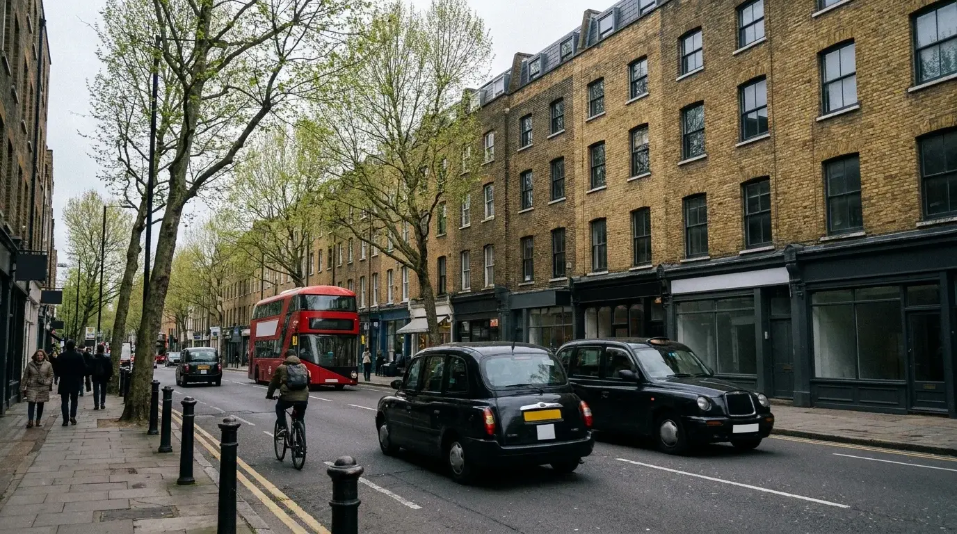
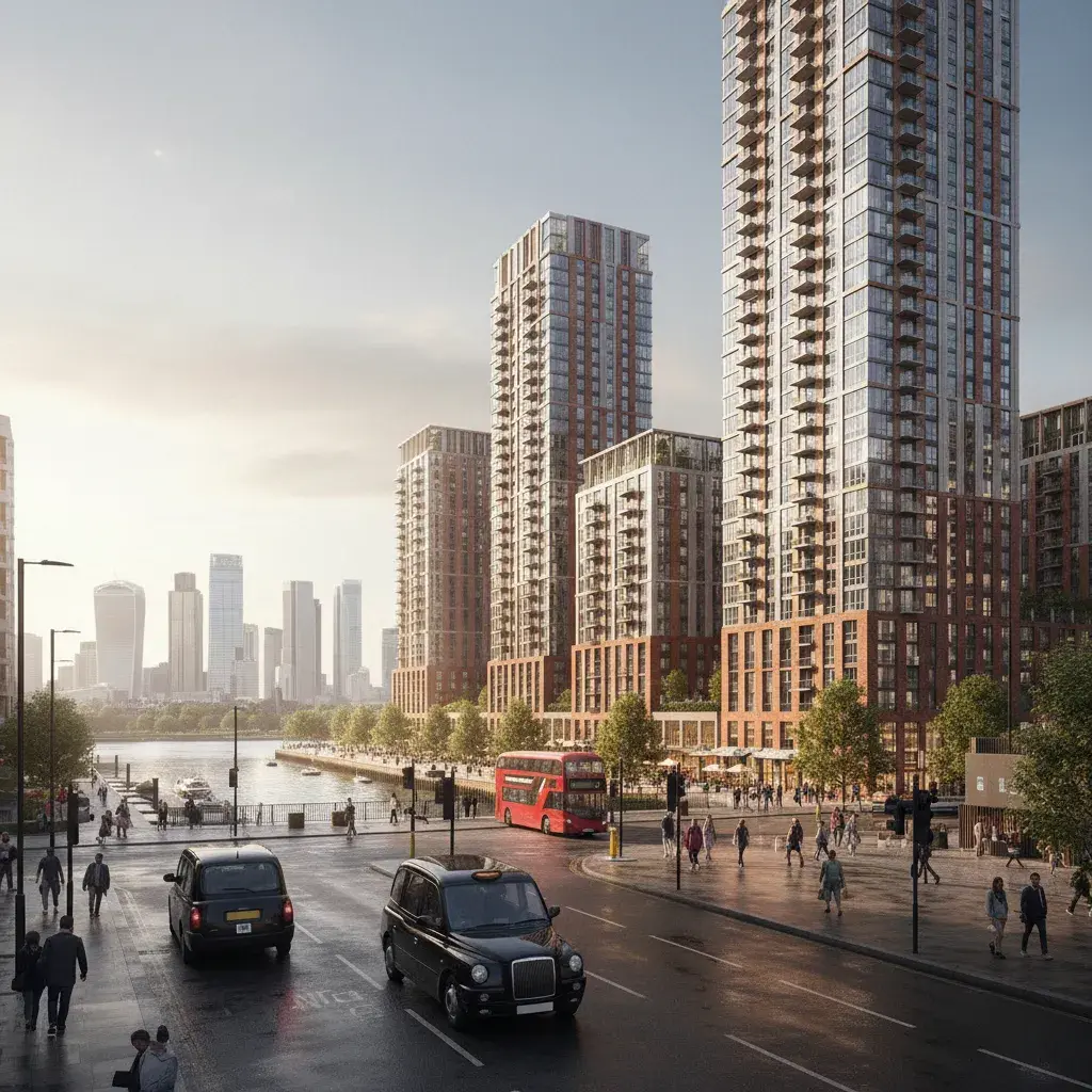
The same proposed City of London tower seen from King Henry's Mound, Richmond Park, the start of LVMF Protected View 1A.1: a ten-mile telephoto sightline along the oak avenue and through the protected corridor to St Paul's Cathedral. Step through the levels to see how each rung carries the proposal differently into the same registered view.


Landscape Institute TGN 06/19 methodology and verified photography camera calibration
Every Accurate Visual Representation (AVR) we deliver complies with the Landscape Institute's Technical Guidance Note (TGN) 06/19. Unlike illustrative marketing renders, verified views are survey-controlled mathematical facts. We employ a georeferenced camera calibration workflow to ensure all architectural visualisations are legally defensible at planning public inquiries and appeals.
Deploying 50mm prime focal lengths and standard 1.65m tripod heights
Baseline photography under TGN 06/19 requires optical parameters that mirror standard human eye-level perspective to prevent visual distortions. We capture our digital plates utilizing:
- Full-Frame DSLR/Mirrorless Sensors: Uncropped spatial captures with fixed exposure thresholds.
- 50mm Normal Prime Lenses: Calibrated focal lengths that eliminate barrel and pincushion radial distortions.
- Standard 1.65m Tripod Height: Representing the statutory human eye-level reference baseline.
- Fixed Camera Settings: Locking manual aperture, white balance, and shutter speeds to record raw local atmospheric conditions.

GPS/RTK coordinate matching, dual-frequency receivers, and OSGB36 grid land surveying
To bind the virtual 3D architectural model to the physical world, survey-grade coordinate markers are collected for each viewpoint by the client's team or an independent chartered land surveyor:
- Dual-Frequency GPS/RTK Receivers: Capturing real-time kinematic coordinates with sub-centimetre field tolerance.
- OSGB36 National Grid Reference: Logging easting, northing, and orthometric height values for each viewpoint position.
- Physical Ground Control Points: Surveying permanent urban landmarks (street signs, building vertices) to act as 3D alignment nodes.
- Sub-Pixel Match Validation: Running programmatic camera-matching algorithms yielding a Root Mean Square (RMS) error under 5mm.
Architectural Visualisations London is not a firm of chartered land surveyors. Survey-grade coordinates are supplied by the client's team or an independent surveyor; we produce the verified views and Accurate Visual Representations from that data.

Producing legally defensible Method Statements for public inquiries
Every verified view package is accompanied by a signed Verification Method Statement. This report outlines the entire data chain, documenting raw EXIF camera metadata, survey coordinates, software steps, and matching tolerances. This ensures your townscape visual evidence stands up to rigorous scrutiny at Planning Inspectorate (PINS) public inquiries and local authority audits.
When you need a verified view: triggers and thresholds
Not every London scheme needs a verified view. A sensitivity threshold set by the LPA at pre-application, the GLA on referral, or Historic England on heritage assets usually triggers the request. Six situations most reliably push a brief into AVR territory.
- Conservation areas and listed building settings.
- Schemes within or adjacent to a designated conservation area, or affecting the setting of a listed building, are routinely asked for AVR Level 2 or 3 viewpoints to evidence the heritage impact.
- LVMF designated views and protected vistas.
- Any scheme inside the viewing corridor, lateral assessment area or wider setting consultation area of an LVMF designated view needs AVR Level 3 evidence following the view-specific guidance.
- Tall buildings and GLA referral thresholds.
- Schemes over 30 m outside the City and Canary Wharf, or over the locally adopted tall-building threshold, trigger GLA Stage 1 / Stage 2 referral and a townscape evidence pack that includes verified views.
- World Heritage Site settings.
- Schemes within the consultation area of the Tower of London, Westminster, Maritime Greenwich or Kew Gardens routinely need AVR Level 3 evidence shared with UNESCO advisors.
- EIA-screened schemes and major applications.
- Schemes of 10 or more residential units, 1,000 m² or more of floorspace, or any EIA-screened proposal where townscape and visual impact is a likely significant effect, will be asked for a TVIA-grade verified-view set.
- Appeals, Section 73 amendments and inquiries.
- Where a refusal goes to PINS, or where a consented scheme is varied through Section 73, the original AVR set is typically re-issued with cumulative consented schemes and additional inspector-set viewpoints.
Recognise your scheme above? We confirm the AVR Level and viewpoint schedule with you and the LPA at scoping, so the evidence base is agreed before any site capture.
Start the verified-view briefWhere the trigger is design intent rather than surveyed accuracy, broader planning application visuals for London borough submissions may be the route instead.
LVMF designated views
The London View Management Framework identifies 27 designated views across four categories. Each carries a defined viewing place, viewing corridor, lateral assessment area and wider setting consultation area. If your scheme sits within or adjacent to any of these, the verified-view brief follows the LVMF view-specific guidance.
London Panoramas
- Alexandra Palace
- Parliament Hill
- Kenwood (Hampstead)
- Primrose Hill
- Greenwich Park
- Blackheath Point
Linear Views
- The Mall
- Westminster Pier to St Paul’s
- King Henry VIII’s Mound, Richmond Park
River Prospects
- Tower Bridge
- London Bridge
- Southwark Bridge
- Millennium Bridge
- Blackfriars Bridge
- Waterloo Bridge
- Hungerford Footbridges
- Westminster Bridge
- Lambeth Bridge
- Albert Bridge
- Chelsea Bridge
- Victoria Embankment
- Jubilee Gardens
Townscape Views
- St James’s Park Bridge
- Whitehall
- Bridge over the Serpentine
- Tower of London setting
- Maritime Greenwich setting
- Palace of Westminster setting
Scope your verified view
Five inputs to scope the brief. The summary on the right updates as you change selections, and the contact form will arrive pre-filled.
Reference matrix: typical scope by site sensitivity
| Site situation | Typical AVR Level | Typical viewpoints | Photography route |
|---|---|---|---|
| Householder or minor extension | 0 | 1 to 2 | Client supplies |
| Infill, non-sensitive | 1 | 3 to 5 | Either |
| Conservation area or tall element | 2 | 4 to 8 | We shoot |
| LVMF view, World Heritage setting, tower | 3 | 8 to 20+ | We shoot, multi-day |
| Appeal or inquiry | 2 to 3, often cumulative | Inspector-set | We shoot |
How we produce a verified view
Six documented stages carry a brief from agreement to delivered evidence set, with the method statement travelling alongside the application through validation, consultation, and appeal where refused. For related CGI work, see our services overview.
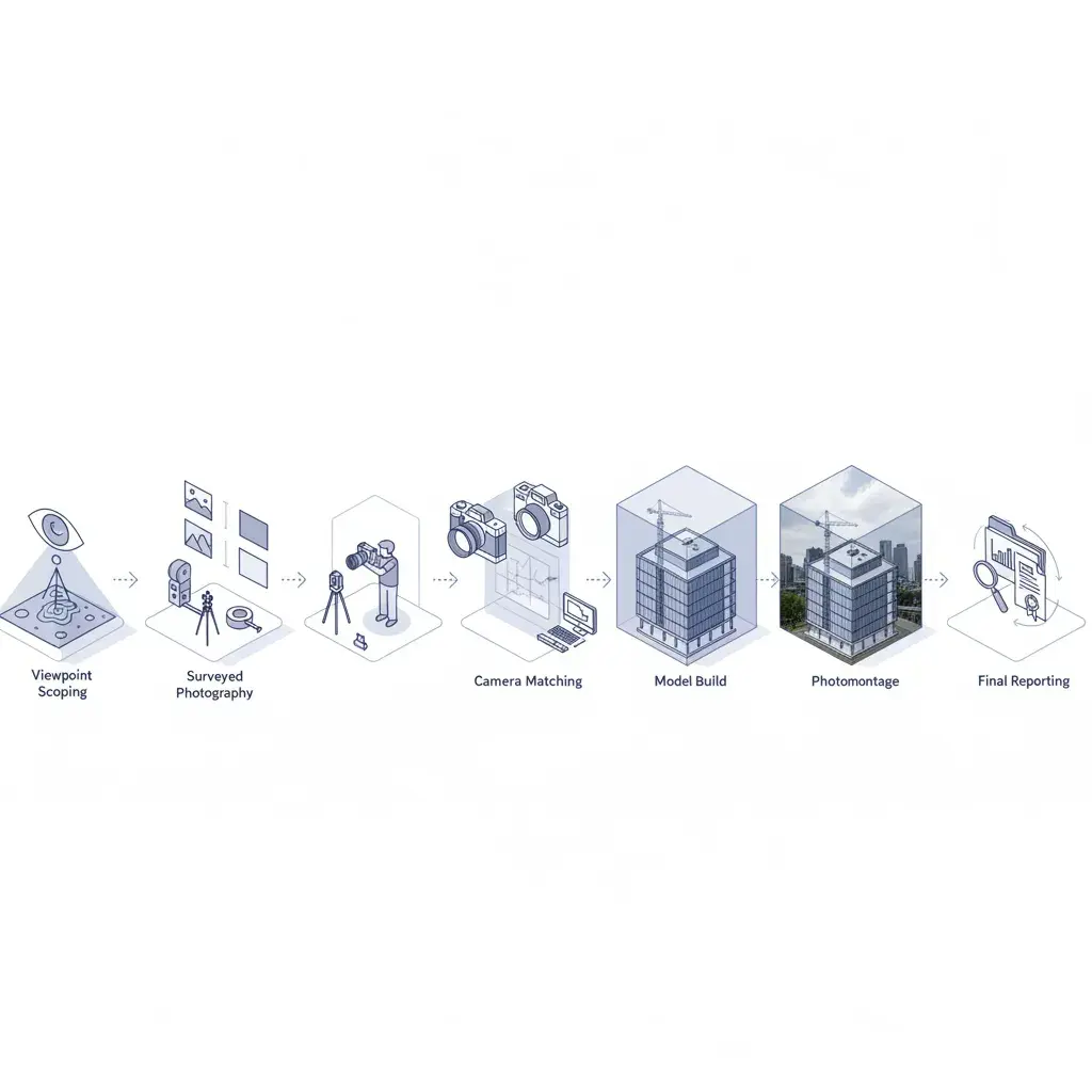
- Agree the viewpoint schedule. Confirm with the LPA, townscape consultant and design team which views will be assessed and at which AVR Level.
- Capture baseline photography and survey data. Full-frame body, 50 mm-equivalent lens, tripod, with date, time, height and bearing recorded against each frame. Client-supplied images are accepted where the same survey parameters are recorded.
- Locate the viewpoints. Record viewpoint locations using OS grid coordinates and control references against fixed visible features in each frame, summarised in a viewpoint location plan issued with the method statement.
- Match the camera in 3D. Align the 3D model camera to each photograph using the viewpoint parameters, drawings and supplied massing.
- Render the proposal at the agreed AVR Level. Wireframe, massing, architectural form or fully materialised render, by viewpoint, per the agreed scope.
- Issue the method statement. Deliver the image set with documentation of inputs, software, datum, and viewpoint parameters.
Turnaround and how a brief moves through
A verified-view commission moves from receipt to delivered evidence set through five gates, summarised below.
- Quote within 24 hours of receiving drawings and intended use.
- Photography on site within 10 working days of the viewpoint schedule being agreed.
- Draft AVR set within 3 weeks of capture, or within 2 weeks where client images are supplied.
- One revision round against design team and consultant comments.
- Final image set and method statement issued ready for inclusion in the planning pack.
Where the application heads to inquiry, or where consultees may request additional views, we build cumulative consented schemes into the photography stage so later revisions are not blocked.
Verified-view costs and what changes the price
The bands below cover photomontage and rendering at 2026 London rates, against a 3D model supplied by the client or design team. Photography is quoted separately based on viewpoint count, access and shoot conditions. Final fees are confirmed against the agreed viewpoint schedule, AVR Level and any cumulative-overlay or appeal-stage requirements.
| Package | Typical scope | Indicative band (GBP, ex VAT) |
|---|---|---|
| Single AVR view, Level 0 or 1 | 1 viewpoint, client-supplied photography, wireline or massing | From £750 |
| Pre-application package, AVR Level 1 or 2 | 3 to 5 viewpoints, client-supplied photography, draft for LPA pre-app | £1,800 to £4,500 |
| Conservation-area submission, AVR Level 2 | 4 to 8 viewpoints, method statement included | £4,500 to £9,500 |
| Major application set, AVR Level 3 | 8 to 12 viewpoints, full method statement | £9,500 to £18,000 |
| LVMF tower or masterplan set, AVR Level 3 | 12 to 20+ viewpoints, cumulative consented overlays, GLA Stage 1 / 2 referral | From £18,000 |
| Appeal re-issue | Inspector-set viewpoints, cumulative update | From £3,500 |
What moves the price: Viewpoint count, AVR Level, cumulative consented schemes supplied for overlay, and revision rounds. The 3D model of the proposed scheme is supplied by the client or design team; we do not produce architectural models in-house. Photography is a separate line item; we can recommend a London townscape photographer or work to your supplied images where the survey parameters are recorded. The method statement is included in every package and not charged separately.
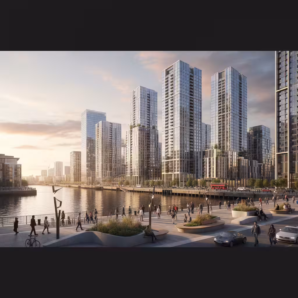
Recent London verified views
Three recent London commissions cover conservation, tower, and masterplan scales. For a worked walkthrough of how the verified-view set and the marketing CGI set were delivered side by side on one east London brief, see the Canary Wharf office tower case study.
Frameworks we work to: LVMF, TGN 06/19 and the Landscape Institute
Every verified view we produce is built to three governing frameworks, so each Accurate Visual Representation meets the standard the application is tested against.
Landscape Institute TGN 06/19
Technical Guidance Note on visual representation. Defines the verified view and AVR Type 1 to Type 4 methodology we produce to.
London View Management Framework
Supplementary Planning Guidance supporting London Plan policies 7.11 and 7.12 on strategic London views, with statutory consultation through the Greater London Authority, Historic England and the Mayor of London.
GLA Visual Representation of Proposed Development
Sets out method statement, baseline photography and 3D-model alignment for tall-building applications. A methodology touchstone, not a claim of LVMF designated-view status on any individual scheme.
Briefs reach us through townscape consultants, masterplanning teams, planning consultants and heritage advisors, on schemes affecting LVMF designated views, World Heritage Site settings, and Section 73 amendments to consented towers. The verified-view package travels with the application through GLA Stage 1 and Stage 2 referrals, LPA validation, and Planning Inspectorate appeal when refused.
Verified views by London borough
Borough validation checklists and townscape expectations vary. Where a scheme touches a designated LVMF view, GLA referral thresholds or a World Heritage Site setting, the AVR Level expected by the LPA usually rises by one tier.
Frequently asked questions about verified views
Do I actually need a verified view for my planning application?
Not every application requires one. Verified views are typically asked for on tall buildings, schemes within or affecting conservation areas, designated London View Management Framework viewpoints, World Heritage Site settings, or any site where the LPA, GLA or Historic England flags townscape and visual impact at pre-application. Householder and minor infill rarely need one.
What is the difference between AVR Level 2 and AVR Level 3?
AVR Level 2 shows architectural form, floors, openings, shading, so the reader understands the building’s scale and articulation in context. AVR Level 3 adds materials, texture and reflections for a fully realised photomontage. Level 3 is used where material treatment is a planning issue or where the scheme sits in a sensitive view.
How many viewpoints does a typical London scheme need?
Small infill schemes often use one to three viewpoints. Mid-scale buildings in conservation areas usually need four to eight. Tall buildings and schemes affecting LVMF designated views can run to 10 to 20 or more, with cumulative views included where consented neighbouring schemes are relevant.
Who agrees the viewpoint list, the applicant or the local authority?
The viewpoint schedule is normally agreed with the LPA at pre-application, sometimes with input from the GLA, Historic England or the townscape consultant. Agreeing the list early prevents wasted effort and avoids a request for additional views later in the determination period.
Can I supply my own photography?
Yes. Client-supplied photography is accepted where the viewpoint, height, bearing, lens and time of capture are recorded. This shortens delivery and reduces the brief. Where the application is in a sensitive context or likely to be tested at appeal, controlled photography on a tripod with a full-frame body and a 50 mm-equivalent lens is the safer route.
Are verified views required for permitted development?
Permitted development rights remove the planning judgement that a verified view supports, so AVRs are not routinely required for PD prior approval. They are still occasionally produced to support neighbour consultation, prior approval narratives, or where the LPA asks for visual evidence on amenity or daylight.
What is the difference between LVIA and TVIA?
A Landscape and Visual Impact Assessment evaluates effects on landscape character and visual receptors, used most often in rural or peri-urban settings. A Townscape and Visual Impact Assessment applies the same logic to urban contexts. London applications typically involve a TVIA, with verified views forming part of the evidence base.
Do verified views need a chartered surveyor sign-off?
Not as a statutory requirement. The Landscape Institute Type 4 visualisation standard and LVMF AVR Level 3 expect verifiable data sources and a documented methodology. Where appeal-grade evidence is required, a chartered surveyor is often involved in capturing or verifying viewpoint locations.
What is the LVMF and how many designated views does it cover?
The London View Management Framework is supplementary planning guidance published by the Mayor of London in March 2012 in support of London Plan policies 7.11 and 7.12. It identifies 27 designated views across four categories: London Panoramas, Linear Views, River Prospects and Townscape Views, each with a defined viewing place, viewing corridor, lateral assessment area and wider setting consultation area.
Can you support an appeal or planning inquiry?
Yes. Where a refusal goes to PINS, additional or revised verified views are often produced to address the inspector’s focus, to add cumulative consented schemes, or to extend the viewpoint set. Earlier briefs are revisited against the appeal statement and updated to match the evidence being tested.
Disclaimer. Architectural Visualisations London is a visualisation studio, not a firm of chartered or regulated land surveyors. Survey-grade viewpoint coordinates are supplied by the client's team or an independent chartered land surveyor. We produce the verified views and Accurate Visual Representations from that surveyed data; we do not offer regulated land-survey services or RICS-chartered surveyor sign-off in our own name.
Request a quote for your London verified view
Send drawings, references, deadlines, and intended use. We will scope the visualisation around the decision it needs to support, and the AVR Level the application actually needs.
Start the brief